Introduction by R. Nicolì
The author of L’isole più famose del mondo descritte da Thomaso Porcacchi da Castiglione arretino was born in Val di Chiana in 1530 and came from a very poor family. He had the opportunity to be educated on humanistic culture thanks to Duke Cosimo I who allowed him to settle in Florence. There he published his first literary works on Virgil: a biography of the author and the translation of The Aeneid Book IV. His life radically changed when he moved to Venice where he met and married the poet Bianca d’Este and came into contact with Gabriele Giolito de’ Ferrari, who published works in vernacular. The author translated Greek and Latin works for the publisher and revised other texts but, in particular, he intervened as a scientific consultant[1]. In Venice he also wrote volumes on various subjects, showing his wide culture that ranges from geography to history and from archaeology to ethnology. Furthermore, Tommaso Porcacchi was responsible for the 16th century editions of Boccaccio’s Laberinto d’amore, Guicciardini’s Storie fiorentine, and Bembo’s Rime.
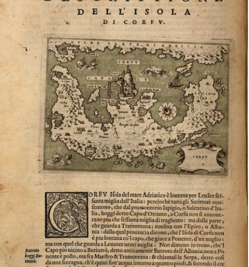
The work proposed for the POLYSEMI Library, selecting those parts related to the description of some Ionian Islands, is an isolario (book island), a particularly flourishing genre during the Renaissance exploration of new sea horizons. It was first published in Venice by Simon Calignani in 1572 and the descriptive parts written by Porcacchi were illustrated with 47 plates, engraved by Girolamo Porro[2] from Padua.
The Battle of Lepanto upset the previous geographical and political balance in the Mediterranean Sea, so as to make the first edition of the Isole obsolete (its compilation must have been completed at the end of 1570, one year before the naval battle). Hence, the second edition published in 1576 will contain also the Descrittione del conflitto navale successo a’ Curzolari nel mar Ionio a VI d’Ottobre MDLXXI. This edition will be re-printed in 1590 without any changes, enriched with a single plate in the 1604 and 1620 editions and re-arranged separating the text from the plates in a late 1686 edition, entitled L’Isole più famose del mondo… Di nuovo corrette, et illustrate con l’aggiunta dell’Istria, et altre Isole, Scogli, e nuove curiosità. Essendovi una distinta descrittione della Città di Costantinopoli, e della Penisola di Morea (Venezia, Pietr’Antonio Bigonci, 1686). The author also adds a dedication in which he justifies this further and late reprint, insisting on the previous editions success.
The cartographic encyclopedia of the islands, which is the precursor of modern cosmography, is a scholarly – although empirical – effort to draw a map of the seas, showing on it the islands and their location in detail. It promotes an alternative system of space, extremely varied and fragmentary, which crosses the traditional continental borders. The imago mundi changes significantly between the 15th and the 16th centuries, both through the Spanish exploration and occupation feats in the west of the New World and through the Portuguese expeditions to the East.
The isolario, which often aims to fix that new image of the world in its pages, is a product of the first modern geographic culture that showed a surprising variety, but was doomed to disappear in the following centuries. Hence, it should be considered as a transition genre that during the Enlightenment will be used to show the misunderstandings about the maritime space perception in a period when the world view changes and it is impossible – also in terms of tools – to document its new contours. However, at the beginning of the 17th century it was still widespread and used especially by travelers on board: the geographical representation of the islands was often accompanied by symbols that signaled low waters and emerging cliffs, whereas the various perspective views of towns and the mountain profiles drawn on the maps revealed the need to describe the territory as seen from the sea. Hence, it was a narrative aimed at offering sailors and various travelers reliable points of reference and visual support, so as to recognize the farthest spaces from the homeland.
In the context of the 16th-century production and diffusion of printed maps, Italy has definitely played a key and valuable role, since its favorable geographical location had made it a commercial power, creating the need for regularly updated and enriched nautical and geographic maps.
The distinctive trait of Porcacchi’s work lies in the use of sea cosmography as a sort of excuse to provide also historical curiosities on the places, in a compendium of mythological and encyclopedic quotations and information on local traditions. Porcacchi definitely succeeded, since L’isole più famose del mondo would have become a real bestseller after the first edition; it was innovative especially thanks to the pictures that accompanied geographical, ethnographic, economic and historical information. In fact, the book was the first isolario to adopt the copperplate engraving technique, then gradually become the normal technique in the illustration of printed books. The plates, drawn by Girolamo Porro with extreme precision, give the text a significant potential for reaching the general public. However, Porro’s maps, beyond their fascination, are hard to interpret in practical terms, since they are small and too rich in information assembled in a limited space.
Hence, the work volumes may be considered the result of a close collaboration between Porcacchi and Porro, who have complementary tasks, as the complete title clearly shows: L’isole più famose del mondo descritte da Thomaso Porcacchi da Castiglione arretino e intagliate da Girolamo Porro padovano.
The place where the book was commissioned and printed surely contributed to its surprising and immediate fame: in the 16th century Venice was more populated than Rome and as early as the end of the 15th century it had supremacy over the publishing context thanks to its role as a center of international commerce, towards Europe and the Mediterranean area.[3]
Porcacchi’s text has an eminent antecedent, the Navigationi et viaggi by Ramusio in three volumes, published in 1550, 1556 and 1559 respectively. It was a monumental cosmographic work resulting from the project of mapping the world, which confirmed the rejection of Ptolemaic geography. The project of the Navigazioni is the most serious effort in the 16th century to organically combine travel literature and cartography. The work L’isole più famose, published little more than a decade later, shares with Ramusio’s text (he was a high official of the ducal chancery) the close attention to the representation of the Venetian maritime empire adopting a procedure of cartographic idealization: the Ionian Islands are described by Porcacchi in their geographical aspect, but are presented in an order that does not correspond to the real itinerary to be followed from one island to the other. In fact, in line with other contemporary writings at the service of Venice, his aim was to emphasize the Republic commercial and political power, according to precise celebration paradigms. Therefore, the division into chapters, at least for the selected parts reproduced for this digital edition, helps to compile a record of Venetian possessions: he starts, after Venice celebration, from the description of the islands that belonged to it (Corfu, Morea, Candia, Cyprus, Rhodes, the Archipelago, Negroponte); then Porcacchi illustrates the islands controlled by others (Sicily, Malta, Corsica, Sardinia, Elba, Mallorca, Menorca, England, Scotland, Ireland, Holland, Iceland, Gotland, Hispaniola, Cuba, St. Lawrence Island, Taprobana, the Moluccas) and concludes with the description of an island that is as big as a continent (Santa Cruz or New World, North America) and then an island as small as a town (Temistitan as depicted by Bordone). Finally, he describes the map of the world in general.
The impressing work written by Porcacchi on the world islands is strongly connoted by the sea presence: he offers the reader a view of geography centered around the sea, in which human settlements surround more or less vast portions of sea, but generating together a spatial continuum.[4] In his preface Porcacchi states: “A questa opinione (pigliandone io solo il primo capo d’historia, cioè che questo nostro mondo sia a guisa d’un’isola, circondato d’ogn’intorno dall’Oceano, e lasciandone il rimanente) trovo che Strabone acconsente nel primo libro, dicendo che tutta la terra è un’Isola, se si guarda al mare, che la circonda, e le sta sopra. Percioche si come nel mar Mediterraneo apparisce Cipro, e la Sardigna; cosi in tutta l’ampiezza del mare apparisce tutta la terra è guisa d’Isola: il che testifica anchora Plinio”. Based on Strabo and Pliny’s writings that he clearly assimilates, he starts to describe the most famous islands, trying to indicate their location and size, the islands nearby, the ports, the main island products and sites, their first inhabitants and history. Basically, he takes inspiration from classical and contemporary writers, in particular as for the anthropological and geographical description.
Furthermore, in the Prologue, the author states he had written his descriptions, which contain innovative elements, not only on the basis of his own studies on classical authors, but also thanks to the collaboration of friends “gentil homini”, humanists, geographers, and scientists, who provided him with the necessary sources, through accounts and notes.
The beginning of the description generally concerns the island’s location; then there is the reference to the name etymology, with the various hypotheses. He follows a sort of pattern, obviously valid for the fragmentary Greek insular world, here reproduced. As specified above, the texts written by Porcacchi add various curiosities on the sites and some fictitious news: they are mostly subjective interpretations, linked to the author’s personality and his cultural world.
For the POLYSEMI Library – besides the Preface, which includes general information and a glossary of the terms used, as well as a more general description of the Archipelago – we have extracted and copied, following the norms below, the sections on Corfu, Cephalonia, Zakynthos and Cerigo that belonged to the Ionian Islands (it is necessary to specify that the current Ionian Islands administrative region does not include Cerigo, today belonging to Attica).
-
See: Claudia Di Filippo Bareggi, Il mestiere di scrivere – Lavoro intellettuale e mercato librario a Venezia nel Cinquecento, Bulzoni, Roma, 1988, p. 84-85. ↑
-
Girolamo Porro (Padua 1520-1604) was an engraver, publisher and drawer. He worked mostly in Venice and was a pupil of Enea Vico. In the second half of the 16th century, many works were illustrated with his engravings: besides the plates for Tommaso Porcacchi’s work, he drew 64 plates for Ptolemy’s Geografia translated by Girolamo Ruscelli and in 1584 he illustrated the Orlando Furioso, published in Venice by Francesco de Franceschi. ↑
-
S. Bifolco, F. Ronca, Cartografia rara italiana: XVI Secolo. L’Italia e i suoi territori. Catalogo ragionato delle carte a Stampa, Edizioni Antiquarius, Roma 2014, p. 29. ↑
-
See: G. Guglielminetti, Il ‘Mondo Nuovo’ come un’isola. Benedetto Bordon e Tommaso Porcacchi, in Zorzi, R. (a cura di) L’epopea delle scoperte, Firenze, Leo S. Olschki 1994, p. 115. ↑
Ergographia
Selected literature